This week, the National Weather Service revised a damage assessment of a tornado that struck Enderlin, North Dakota. The tornado was part of a three-day-long tornado outbreak that occurred between June 19-22 of this year. The event in total produced 41 tornadoes according to the NWS.
Previously, the National Weather Service gave the Enderlin tornado an EF3 rating on the Enhanced Fujita Scale. However, upon revising the damage assessment, the NWS discovered the tornado had thrown train cars hundreds of yards and produced high-end damage to well-constructed homes. The National Weather Service in Grand Forks, ND announced on the morning of October 6th that the Enderlin tornado would be upgraded to EF5 status.
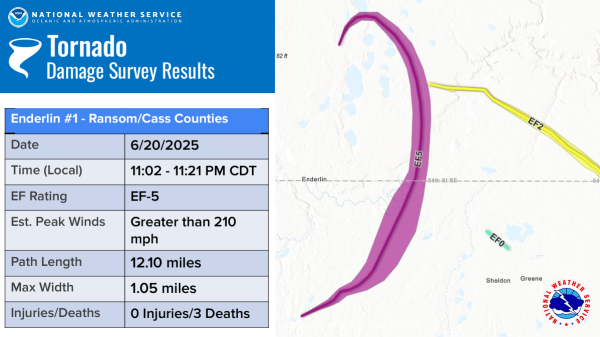
In the statement, the NWS had estimated the tornado’s peak wind speed to be no less than 210 mph, among the highest NWS estimates for a tornado. The NWS also said the wind speed estimates corroborated weather radar data. This new rating means the Enderlin tornado is the first confirmed EF5 in the United States since 2013. Breaking a record that lasted twelve years.

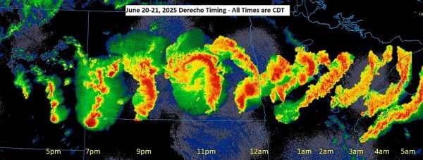
Compilation of radar imagery of the June 19-22 derecho. The derecho formed in eastern Montana and continued into northern Wisconsin.
Tornadoes in the US and Canada are rated by damage, not by recorded wind speed. National Weather Service offices send teams to assess tornado damage after an event to rate and estimate the event. The Enderlin tornado occurred at night, and the next day, NWS Grand Forks, as well as other groups such as the Northern Tornadoes Project, began assessing damage. “We send out some of our meteorologists down there to examine the damage and take photos.” Austin Perroux, staff meteorologist at NWS Grand Forks, said.
“The Enhanced Fujita Scale is an evaluation of what happened,” Meteorologist-in-Charge Michael Cantin at NWS Boise said in an exclusive interview. “Scientists have done many studies to understand how much wind it takes to cause certain types of damage, such as lifting a roof off a house or stripping bark off a tree.”
“The Enderlin tornado was originally rated an EF3; however, they used supplementary data to revise the rating,” Cantin explained. “A study showed that it takes winds of more than 210 miles per hour to pick up and throw grain-filled train cars, and that is the kind of damage they saw.”

Official NOAA graphic of Enderlin, ND EF5 tornado damage path.
“Any time there’s tornado damage at EF3 or higher, we have what is called a Quick Response Team or QRT. These are specialists within the weather service who specifically research damage from severe weather events.” However, meteorologists on site began suspecting the tornado had much greater damage than a typical EF3. “What really prompted us to look closer was these train cars that were observed to have been lifted and thrown off the tracks themselves. They were thrown about 145 meters off the tracks, which keyed our interest in a potential higher rating.” Perroux said.
The Enderlin, ND, tornado was not an isolated event. It was part of a phenomenon known as a derecho. “Derechos are a line of thunderstorms that produce very significant wind. What sets them apart is their duration and how far they go.” Perroux said. According to Perroux, tornadic thunderstorms form ahead of derechos if conditions are ripe for tornadic activity. Derechos have a more widespread effect as they cross far distances, sometimes half the width of the US mainland, and bring destructive wind and hail.
Another meteorologist at NWS Grand Forks, Carl Jones, recounted how we worked at the office during the event itself in an email correspondence. “I was serving as one of the warning meteorologists that day. I would describe the workplace as chaotic, but in an organized and collected fashion. It was surprisingly noisy due to the amount of verbal information sharing.” Jones added that there was a large volume of phone calls to the NWS office and NOAA Weather Radio monitors constantly operating. “It was surreal seeing the magnitude of impacts occurring in real-time,” Jones said.
The Enderlin, ND tornado has now tied the record for the highest estimated winds by the National Weather Service specifically. The NWS now estimates the tornado to have wind speeds no less than 210 mph, sharing the record with the 2011 El Reno, OK tornado. The Enderlin, ND, tornado was on the ground for 18 minutes.


